


介绍 Austrian Map mobile
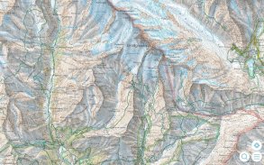
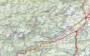
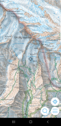
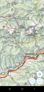
The Austrian Map mobile (AMap mobile) contains the digital maps of Austria including hill shading, geographic names database “Geonam” and the digital elevation model. This digital product of the Bundesamt für Eich- und Vermessungswesen (BEV) offers high quality topographic maps and a user-friendly interface with extensive functionality.
Maps and data available in the Austrian Map mobile:
* Overview Map 1:1 Million (free of charge)
* Cartographic model 1:500 000 (free of charge)
* Cartographic model 1:250 000
* Cartographic model 1:50 000
The app contains a map tile contingent of 550 tiles, which corresponds to 550 km ² in the scale 1:50 000 (no specific area, maps free to choose). This allows to test the capabilities of the AMap mobile in a specific area. Additional areas may be downloaded at will.
Functions of Austrian Map mobile:
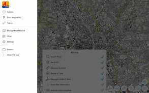
* Search by toponym or search by coordinates
* GPS features: Display of the location, "moving map", compass support, routing along tracks
* Insert, edit and share POIs (Points of Interest)
* Recording and exporting tracks (tracks can be imported into AMap Fly)
* meta data about the used map sheets
奥地利地图移动(AMAP移动)包含奥地利的数字地图,包括山上的阴影,地名数据库“Geonam”和数字高程模型。这个数字Bundesamt献给Eich- UND Vermessungswesen(BEV)的产品提供了高品质的地形图和具有丰富功能的用户友好界面。
地图和奥地利地图移动提供的数据:
*概述地图1:100万(免费)
*制图模式1:500 000(免费)
*制图模式1:250 000
*制图模式1:5万
该应用中包含的地图瓦片队伍550瓦,这相当于550平方公里的规模1时50 000(没有具体的区域中,映射自由选择)。这允许测试在特定的区域中的AMAP移动的能力。其他地区可以随意下载。
奥地图的移动功能:
*由坐标地名或搜索搜索
* GPS功能:显示的位置,“移动地图”,罗盘的支持,路由沿轨道
*插入,编辑和共享的POI(兴趣点)
*录音和出口轨道(轨道可以导入到AMAP飞)
*关于使用地图图幅的元数据
Austrian Map mobile - 版本2.1.3
(20-10-2022)Austrian Map mobile - APK信息
APK版本: 2.1.3程序包: com.garzotto.amma同类应用
您可能还会喜欢……


